Latitude
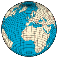
In geography , latitude is a geographic coordinate that specifies the north – south position of a point on the Earth's surface. Latitude is an angle (defined below) which ranges from 0° at the Equator to 90° (North or South) at the poles. Lines of constant latitude, or parallels , run east–west as circles parallel to the equator. Latitude is used together with longitude to specify the precise location of features on the surface of the Earth. On its own, the term latitude should be taken to be the geodetic latitude as defined below. Briefly, geodetic latitude at a point is the angle formed by the vector perpendicular (or normal ) to the ellipsoidal surface from that point, and the equatorial plane. Also defined are six auxiliary latitudes which are used in special applications.
Page Revisions
| Year | Metadata | Sections | Top Words | First Paragraph |
| 2018 |
240049 characters 31 sections 69 paragraphs 24 images 289 internal links 28 external links |
ellipsoid 0.491 latitude 0.299 geodetic 0.272 projection 0.196 reference 0.147 φ 0.144 auxiliary 0.142 meridian 0.138 geoid 0.137 coordinate 0.125 conformal 0.122 latitudes 0.119 parallels 0.116 sphere 0.112 arc 0.111 |
In geography , latitude is a geographic coordinate that specifies the north – south position of a point on the Earth's surface. Latitude is an angle (defined below) which ranges from 0° at the Equator to 90° (North or South) at the poles. Lines of constant latitude, or parallels , run east–west as circles parallel to the equator. Latitude is used together with longitude to specify the precise location of features on the surface of the Earth. On its own, the term latitude should be taken to be the geodetic latitude as defined below. Briefly, geodetic latitude at a point is the angle formed by the vector perpendicular (or normal ) to the ellipsoidal surface from that point, and the equatorial plane. Also defined are six auxiliary latitudes which are used in special applications. |
|
| 2017 |
231353 characters 29 sections 68 paragraphs 22 images 287 internal links 26 external links |
ellipsoid 0.506 latitude 0.286 geodetic 0.267 projection 0.202 reference 0.157 meridian 0.142 geoid 0.141 φ 0.137 auxiliary 0.135 coordinate 0.129 conformal 0.126 parallels 0.120 latitudes 0.117 sphere 0.116 arc 0.115 |
In geography , latitude is a geographic coordinate that specifies the north – south position of a point on the Earth's surface. Latitude is an angle (defined below) which ranges from 0° at the Equator to 90° (North or South) at the poles. Lines of constant latitude, or parallels , run east–west as circles parallel to the equator. Latitude is used together with longitude to specify the precise location of features on the surface of the Earth. Without qualification the term latitude should be taken to be the geodetic latitude as defined in the following sections. Also defined are six auxiliary latitudes which are used in special applications. |
|
| 2016 |
236462 characters 30 sections 75 paragraphs 23 images 307 internal links 26 external links |
2. History of latitude measurements |
ellipsoid 0.506 latitude 0.283 geodetic 0.243 projection 0.202 reference 0.157 meridian 0.142 geoid 0.141 φ 0.137 coordinate 0.129 conformal 0.126 auxiliary 0.125 parallels 0.120 latitudes 0.117 arc 0.115 coordinates 0.114 |
In geography , latitude is a geographic coordinate that specifies the north–south position of a point on the Earth's surface. Latitude is an angle (defined below) which ranges from 0° at the Equator to 90° (North or South) at the poles. Lines of constant latitude, or parallels , run east–west as circles parallel to the equator. Latitude is used together with longitude to specify the precise location of features on the surface of the Earth. |
| 2015 |
199787 characters 28 sections 68 paragraphs 21 images 213 internal links 25 external links |
ellipsoid 0.502 latitude 0.269 geodetic 0.259 projection 0.204 reference 0.159 geoid 0.143 meridian 0.137 mercator 0.129 conformal 0.127 φ 0.127 auxiliary 0.127 latitudes 0.124 parallels 0.121 coordinate 0.121 coordinates 0.116 |
In geography , latitude (φ) is a geographic coordinate that specifies the north-south position of a point on the Earth's surface. Latitude is an angle (defined below) which ranges from 0° at the Equator to 90° (North or South) at the poles. Lines of constant latitude, or parallels , run east-west as circles parallel to the equator. Latitude is used together with longitude to specify the precise location of features on the surface of the Earth. Two levels of abstraction are employed in the definition of these coordinates. In the first step the physical surface is modelled by the geoid , a surface which approximates the mean sea level over the oceans and its continuation under the land masses. The second step is to approximate the geoid by a mathematically simpler reference surface. The simplest choice for the reference surface is a sphere , but the geoid is more accurately modelled by an ellipsoid . The definitions of latitude and longitude on such reference surfaces are detailed in the following sections. Lines of constant latitude and longitude together constitute a graticule on the reference surface. The latitude of a point on the actual surface is that of the corresponding point on the reference surface, the correspondence being along the normal to the reference surface which passes through the point on the physical surface. Latitude and longitude together with some specification of height constitute a geographic coordinate system as defined in the specification of the ISO 19111 standard. [1] |
|
| 2014 |
201517 characters 28 sections 68 paragraphs 23 images 222 internal links 25 external links |
ellipsoid 0.503 latitude 0.269 geodetic 0.259 projection 0.205 reference 0.159 geoid 0.143 meridian 0.137 mercator 0.130 conformal 0.127 φ 0.127 auxiliary 0.127 latitudes 0.124 parallels 0.121 coordinate 0.121 coordinates 0.116 |
In geography , latitude (φ) is a geographic coordinate that specifies the north-south position of a point on the Earth's surface. Latitude is an angle (defined below) which ranges from 0° at the Equator to 90° (North or South) at the poles. Lines of constant latitude, or parallels , run east–west as circles parallel to the equator. Latitude is used together with longitude to specify the precise location of features on the surface of the Earth. Two levels of abstraction are employed in the definition of these coordinates. In the first step the physical surface is modelled by the geoid , a surface which approximates the mean sea level over the oceans and its continuation under the land masses. The second step is to approximate the geoid by a mathematically simpler reference surface. The simplest choice for the reference surface is a sphere , but the geoid is more accurately modelled by an ellipsoid . The definitions of latitude and longitude on such reference surfaces are detailed in the following sections. Lines of constant latitude and longitude together constitute a graticule on the reference surface. The latitude of a point on the actual surface is that of the corresponding point on the reference surface, the correspondence being along the normal to the reference surface which passes through the point on the physical surface. Latitude and longitude together with some specification of height constitute a geographic coordinate system as defined in the specification of the ISO 19111 standard. [1] |
|
| 2013 |
198410 characters 28 sections 68 paragraphs 21 images 211 internal links 25 external links |
4. Numerical comparison of auxiliary latitudes |
ellipsoid 0.504 latitude 0.266 geodetic 0.259 projection 0.205 reference 0.159 geoid 0.143 meridian 0.137 mercator 0.130 conformal 0.127 φ 0.127 auxiliary 0.127 latitudes 0.124 parallels 0.121 coordinate 0.121 coordinates 0.116 |
In geography , latitude (φ) is a geographic coordinate that specifies the north-south position of a point on the Earth's surface. Latitude is an angle (defined below) which ranges from 0° at the Equator to 90° (North or South) at the poles. Lines of constant latitude, or parallels , run east–west as circles parallel to the equator. Latitude is used together with longitude to specify the precise location of features on the surface of the Earth. Since the actual physical surface of the Earth is too complex for mathematical analysis, two levels of abstraction are employed in the definition of these coordinates. In the first step the physical surface is modelled by the geoid , a surface which approximates the mean sea level over the oceans and its continuation under the land masses. The second step is to approximate the geoid by a mathematically simpler reference surface. The simplest choice for the reference surface is a sphere , but the geoid is more accurately modelled by an ellipsoid . The definitions of latitude and longitude on such reference surfaces are detailed in the following sections. Lines of constant latitude and longitude together constitute a graticule on the reference surface. The latitude of a point on the actual surface is that of the corresponding point on the reference surface, the correspondence being along the normal to the reference surface which passes through the point on the physical surface. Latitude and longitude together with some specification of height constitute a geographic coordinate system as defined in the specification of the ISO 19111 standard. [1] |
| 2012 |
188049 characters 27 sections 67 paragraphs 22 images 207 internal links 25 external links |
4. Numerical comparison of auxiliary latitudes |
ellipsoid 0.526 geodetic 0.258 latitude 0.250 projection 0.203 reference 0.172 meridian 0.143 parallels 0.127 coordinate 0.127 coordinates 0.121 φ 0.121 mercator 0.120 latitudes 0.119 ellipsoids 0.116 sphere 0.116 projections 0.113 |
In geography , latitude is a geographic coordinate that specifies the north-south position of a point on the Earth's surface. Lines of constant latitude, or parallels , run east–west as circles parallel to the equator. Latitude is an angle (defined below) which ranges from 0° at the Equator to 90° (North or South) at the poles. |
| 2011 |
189603 characters 27 sections 70 paragraphs 22 images 202 internal links 21 external links |
4. Numerical comparison of auxiliary latitudes |
ellipsoid 0.525 geodetic 0.258 latitude 0.255 projection 0.203 reference 0.172 φ 0.145 meridian 0.143 coordinate 0.127 coordinates 0.121 mercator 0.120 latitudes 0.119 ellipsoids 0.116 sphere 0.115 parallels 0.113 projections 0.113 |
In geography , Latitude is a geographic coordinate that specifies the north-south position of a point on the Earth's surface. Latitude ranges from 0° at the Equator to 90° (North or South) at the poles. Latitude is used together with longitude to specify the precise location of features on the surface of the Earth. Since the actual physical surface of the Earth is too complex for mathematical analysis two levels of abstraction are employed in the definition of these coordinates. In the first step the physical surface is modelled by the geoid , a surface which approximates the mean sea level over the oceans and its continuation under the land masses. The second step is to approximate the geoid by a mathematically simpler reference surface. The simplest choice for the reference surface is a sphere , but the geoid is more accurately modelled by an ellipsoid . The definitions of latitude and longitude on such reference surfaces are detailed in the following sections. Lines of constant latitude and longitude together constitute a graticule on the reference surface. The latitude of a point on the actual surface is that of the corresponding point on the reference surface, the correspondence being along the normal to the reference surface which passes through the point on the physical surface. Latitude and longitude together with some specification of height constitute a geographic coordinate system as defined in the specification of the ISO 19111 standard. [1] |
| 2010 |
179859 characters 22 sections 28 paragraphs 18 images 338 internal links 14 external links |
latitude 0.361 displaystyle 0.356 curvature 0.280 radius 0.212 ellipsoid 0.160 equatorial 0.157 α 0.156 geodetic 0.143 equator 0.137 spheroid 0.126 phi 0.119 plane 0.115 latitudes 0.113 ϕ 0.111 cos 0.110 |
In geography , the latitude of a location on the Earth is the angular distance of that location north or south of the equator . The latitude is an angle , and is usually measured in degrees (marked with °). The equator has a latitude of 0°, the North pole has a latitude of 90° north (written 90° N or +90°), and the South pole has a latitude of 90° south (written 90° S or −90°). Together, latitude and longitude can be used as a geographic coordinate system to specify any location on the globe. |
|
| 2009 |
155866 characters 20 sections 27 paragraphs 17 images 225 internal links 14 external links |
displaystyle 0.364 latitude 0.297 curvature 0.287 radius 0.231 ellipsoid 0.164 equator 0.163 equatorial 0.161 ε 0.152 geodetic 0.146 flattening 0.134 phi 0.122 plane 0.118 ϕ 0.113 cos 0.113 decimal 0.110 |
Latitude , usually denoted by the Greek letter phi ( φ ) gives the location of a place on Earth (or other planetary body) north or south of the equator . Lines of Latitude are the imaginary horizontal lines shown running east-to-west (or west to east) on maps (particularly so in the Mercator projection ) that run either north or south of the equator. Technically, latitude is an angular measurement in degrees (marked with °) ranging from 0° at the equator ( low latitude ) to 90° at the poles (90° N or +90° for the North Pole and 90° S or −90° for the South Pole ). The latitude is approximately the angle between straight up at the surface (the zenith ) and the sun at an equinox . The complementary angle of a latitude is called the colatitude . |
|
| 2008 |
151110 characters 21 sections 26 paragraphs 14 images 212 internal links 19 external links |
displaystyle 0.373 curvature 0.311 latitude 0.298 radius 0.221 ε 0.165 equatorial 0.159 equator 0.152 ellipsoid 0.152 geodetic 0.127 cos 0.122 decimal 0.119 spheroid 0.117 flattening 0.116 circle 0.114 plane 0.113 |
Latitude , usually denoted symbolically by the Greek letter phi ( Φ ) gives the location of a place on Earth (or other planetary body) north or south of the equator . Lines of Latitude are the horizontal lines shown running east-to-west on maps. Technically, latitude is an angular measurement in degrees (marked with °) ranging from 0° at the equator (low latitude) to 90° at the poles (90° N for the North Pole or 90° S for the South Pole ; high latitude). The complementary angle of a latitude is called the colatitude . |
|
| 2007 |
104285 characters 19 sections 23 paragraphs 5 images 99 internal links 16 external links |
curvature 0.370 latitude 0.299 radius 0.263 equatorial 0.224 displaystyle 0.209 ellipsoid 0.181 equator 0.168 decimal 0.141 degree 0.136 circle 0.136 plane 0.135 phi 0.118 radii 0.110 length 0.100 south 0.099 |
Latitude , usually denoted symbolically by the Greek letter phi , , gives the location of a place on Earth north or south of the equator . Lines of Latitude are the horizontal lines shown running east-to-west on maps. Technically, Latitude is an angular measurement in degrees (marked with °) ranging from 0° at the Equator (low latitude) to 90° at the poles (90° N for the North Pole or 90° S for the South Pole ; high latitude). The complementary angle of a latitude is called the colatitude . |
|
| 2006 |
80912 characters 20 sections 27 paragraphs 3 images 112 internal links 10 external links |
latitude 0.331 wealthiest 0.240 europe 0.192 equator 0.165 diseases 0.162 africa 0.156 continents 0.148 wealth 0.148 poorest 0.144 inhabitants 0.140 decimal 0.139 circle 0.134 displaystyle 0.129 continent 0.119 wealthy 0.099 |
Latitude , usually denoted symbolically by the Greek letter phi , , gives the location of a place on Earth north or south of the Equator . Latitude is an angular measurement in degrees (marked with °) ranging from 0° at the Equator (low latitude) to 90° at the poles (90° N for the North Pole or 90° S for the South Pole ; high latitude). The complementary angle of a latitude is called the colatitude . |
|
| 2005 |
49412 characters 19 sections 19 paragraphs 1 images 89 internal links 6 external links |
latitude 0.302 wealthiest 0.271 tropics 0.183 diseases 0.183 europe 0.168 continents 0.168 inhabitants 0.159 decimal 0.157 equator 0.155 africa 0.147 continent 0.134 wealth 0.134 weather 0.121 comfortable 0.118 wealthy 0.112 |
Latitude , sometimes denoted by the Greek letter φ , gives the location of a place on Earth north or south of the Equator . Latitude is an angular measurement ranging from 0° at the Equator to 90° at the poles (90º N or 90º S). Co-latitude is the complement of latitude. |
|
| 2004 |
33603 characters 5 sections 25 paragraphs 1 images 66 internal links 6 external links |
latitude 0.357 wealthiest 0.291 equator 0.200 diseases 0.196 europe 0.180 continents 0.180 africa 0.157 continent 0.144 wealth 0.144 wealthy 0.120 tropics 0.118 technologies 0.109 circle 0.108 tropic 0.105 nations 0.104 |
Latitude is an angular measurement ranging from 0° at the Equator to 90° at the poles. Other latitudes of particular importance are the Tropic of Cancer (latitude 23°27′ north), the Tropic of Capricorn (latitude 23°27′ south), the Arctic Circle (latitude 66°33′ north), and the Antarctic Circle (latitude 66°33′ south). Only at latitudes between the Tropics is it possible for the sun to be at the zenith . Only north of the Arctic Circle or south of the Antarctic Circle is the midnight sun possible. |
|
| 2003 |
3170 characters 1 sections 6 paragraphs 0 images 19 internal links 0 external links |
latitude 0.384 circle 0.372 tropic 0.362 antarctic 0.232 arctic 0.180 equator 0.172 weathers 0.169 capricorn 0.161 parallel 0.156 φ 0.145 midnight 0.145 coplanar 0.145 latitudes 0.136 tropics 0.135 nautical 0.133 |
|
|
| 2002 |
2875 characters 0 sections 6 paragraphs 0 images 17 internal links 0 external links |
latitude 0.398 circle 0.385 tropic 0.375 antarctic 0.240 arctic 0.186 equator 0.179 capricorn 0.167 parallel 0.161 horse 0.155 midnight 0.151 coplanar 0.151 latitudes 0.141 tropics 0.140 nautical 0.137 zenith 0.133 |
Latitude gives the location of a place north or south of the equator . Latitude is an angular measurement ranging from 0° at the equator to 90° at the poles. |
|
| 2001 |
2736 characters 0 sections 6 paragraphs 0 images 16 internal links 0 external links |
circle 0.396 tropic 0.385 latitude 0.368 antarctic 0.247 arctic 0.192 equator 0.184 capricorn 0.172 parallel 0.166 midnight 0.155 coplanar 0.155 latitudes 0.145 tropics 0.144 nautical 0.141 zenith 0.136 south 0.134 |
Latitude gives the location of a place north or south of the equator . Latitude is an angular measurement ranging from 0° at the equator to 90° at the poles. |
